
Amber Valley: Local Plan Paves Way for 10,000 Houses in 10 years
Local Democracy Reporter: Eddie Bisknell
As part of a bid to find space for nearly 10,000 homes around Alfreton, Belper, Heanor, Ripley and the edge of Derby in the next 10 years, planners have earmarked 19 sites for housing.
The proposals, put forward in the Submission Amber Valley Local Plan, form a blueprint for residential development across the region up to 2028.
Laid out in the plan are aims to build 9,770 homes in the next decade – 575 each year.
The next step is for a Government inspector to independently assess the proposals, before potential approval by councillors.
The 19 designated sites for new housing development are:
- Cotes Park, Birchwood Lane, Somercotes – 210
- Amber Valley Rugby Club, Lower Somercotes, Somercotes – 200
- Somercotes Hill, Somercotes – 180
- Belper Lane, Belper – 65
- Leafy Lane, Heanor – 12
- Newlands/Taylor Lane, Heanor – 500
- Thorpes Road, Heanor – 35
- Whysall Street, Heanor – 76
- Hall Road, Langley Mill – 80
- Asher Lane Business Park (North), Ripley – 85
- Asher Lane Business Park (South), Ripley – 92
- Butterley Hill, Ripley – 100
- Moseley Street, Ripley – 10
- Radbourne Lane (North), Mackworth – 600
- Radbourne Lane (South), Mackworth – 70
- The Common, Crich – 65
- Duffield Depot, Derby Road, Duffield – 16
- Wessington Lane, South Wingfield – 40
- Land north of Denby – 1,100
As of August last year, when the housing target was calculated, council officers found that after ruling out the house plans which have either been built or expected, sites must be set aside for a further 2,243 homes.
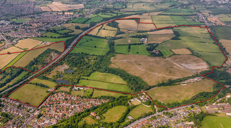
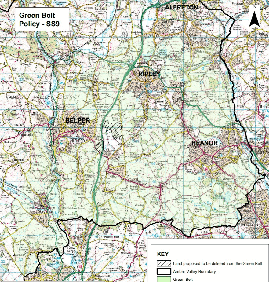
Nearly 200 acres of green belt land to the north of Denby, known as Cinderhill, would have its status “deleted” to pave the way for 3,000 houses and nearly 30 acres of business and industrial space, and a new junction off the A38 would be created to serve the development.
The developer, Cinderhill Harworth, has told the council that it could build 1,100 houses for this plot within the Local Plan period.
Its plans also include a new primary school and the remediation of tar pits – the disposal of tar and ash waste left over from clay extraction.
A Local Plan is a blueprint for future development. Councils are encouraged to create one to show that their area has a five-year housing supply and to lay out which plots of land are preferred for new housing, businesses or public space.
After appealing for potential sites for large housing schemes, 133 proposals came forward, but just 19 of these have been approved – including the 1,100 homes from the Cinderhill scheme – after officers undertook rigorous assessments.
This includes whether developments can be built in the next 10 years and if they are best placed for road access and local services such as schools, hospitals and shops.
The council has also earmarked 113 acres of land for new businesses and industrial development.
It also states that the town centres of Alfreton, Belper, Heanor and Ripley have been prioritised for new shops and offices, cafes, restaurants, hotels and takeaways.
Vacant shops and offices will have their upper floors converted into flats.
Langley Mill has been dubbed the district centre and will be the focus of further employment needs, followed by the “local centres” of Codnor, Duffield, Leabrooks and Somercotes.
Proposals for housing schemes on these sites will be permitted by the borough council as long as the developers provide money for infrastructure to support their plans, such as schools, libraries, healthcare centres, play areas, football pitches, open space and road access.
These would range in size depending on the number of houses the developer intends to build.
Borough council officers say that sites which have had several applications refused but approved on appeal will be among the priorities to be earmarked in the Local Plan.
Up to 30 per cent of housing projects of 15 homes or are “expected” to be affordable housing.
Also, mentioned in the plan is that 10 pitches will be eventually be identified for gypsies, travellers and travelling showpeople.
The sites earmarked for business and industrial development are:
- Lily Street Farm, Swanwick – 35 acres
- Shipley Lakeside, Shipley – three acres
- Alfreton Trading Estate, Somercotes – four acres
- Denby Hall, Denby – nine acres
- Land north of Denby – 30 acres
Land at East Mill, West Mill and North Mill in Belper has been set aside as priorities for mixed use areas, with approval on the cards for shops, hotels, restaurants, homes and storage companies.
As part of the Submission Local Plan, borough council officers wrote: “By 2028, Amber Valley will have healthy, vibrant and sustainable communities with a wide range of quality facilities and services for all sectors of the population.
“Residents will enjoy an excellent quality of life and the Borough will be an attractive place for people to live, work and visit.
“These communities will be safe and all will be able to live and visit these areas without the fear of crime.
“Most new growth will be concentrated in the most sustainable locations outside the Green Belt, be of a high quality of design, improve the vibrancy of these areas and respect their local distinctiveness.
“The creation of a new mixed use development at land north of Denby will have made a significant contribution to meeting the Borough’s housing needs.
“There will be a network of pedestrian and cycling linkages across the borough to improve footfall and access recreational areas, improved areas of public open space and a wide range of services.
“Improvements to the transport infrastructure will have been carried out and all new development will be well served by public footpaths, cycle routes and public transport to reduce dependency on the car and make best use of existing infrastructure.
“More affordable housing will be provided with new housing designed to provide for the needs of all sectors of the community.
“Existing traffic congestion that currently exists within all of the four market town centres will have been reduced and the quality of the environment in the town centres will have been improved.”

AVBC holds a register of Assets of Community Value… neither the WHS or any of its buffer Zone is currently recorded on this Register. IT COULD AND SHOULD BE. Wikipedia states that any voluntary or community organisation can nominate an asset to be included on a local authorities register of assets of community value (AVC). One recorded as such, an AVC is afforded additional protection from development as it is a material planning consideration and can be used by the planning inspectorate as a factor in refusing planning permission or for refusing change of use or demolition. Registration of the Worlds Heritage Zone would exclude Belper Lane and Bullsmoor from any development. Finally, why is the massive brownfield site at Bullbridge not cited as a development site?