
Community Rallies Together to Fight Bessalone Housing Plans
The Planning Application submitted by JC Balls to develop Green Belt land at Bessalone Hill that separates Belper from Nether Heage has united most of Belper in vehement opposition. Newly elected Labour Councillor, Ben Bellamy, is teaming up with Conservative former Mayor, Joe Booth, to lead the fight. Protect Belper, the organisation set up to fight housing plans at Bullsmoor, have also entered the fray.
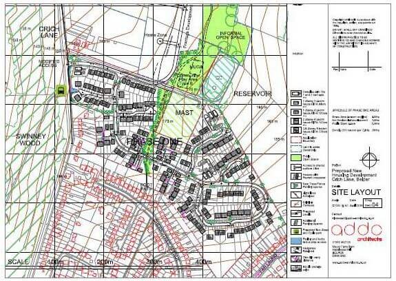
The plans submitted are for ‘Phase 1’ and include provision of 201 houses. Phase 2 is being talked about as an additional 40 houses per year being built to close the gap between Belper and Nether Heage even more.
Whilst planning applications are often successful, permission can be refused if challenged correctly. Nearby South Wingfield is one such success story and there is plenty to learn from their recent experience of dealing with Amber Valley Borough Council.
Cllr Ben Bellamy is urging people to visit the Amber Valley Planning web page: http://www.ambervalley.gov.uk/environment-and-planning/planning/development-management/planning-applications/view-a-planning-application.aspx and search for application reference number AVA/2016/0535. Then to let Amber Valley know what you think of the application.
You can do this either via the Amber Valley website or in writing to the council.
Grounds for objection
There are restrictions to the reasons individuals or organisations can use as the basis for objections. Objections based on any of the following are not relevant or material planning considerations and will not be taken into consideration.
- Loss of View
- Loss of Property Value
- Boundary/Land Ownership Disputes
- Private Rights of Way
- Competition
- Moral Objection
- Tenure
- Covenants
Ben Bellamy suggests that there are no grounds to argue that the green belt land should be developed, and that the application fails the test 9.89 of the government planning practice guidance. “9.89 A local planning authority should regard the construction of new buildings as inappropriate in Green Belt.”
Green Belt land can only be developed in any of these circumstances:
- buildings for agriculture and forestry;
- provision of appropriate facilities for outdoor sport, outdoor recreation and for cemeteries, as long as it preserves the openness of the Green Belt and does not conflict with the purposes of including land within it;
- the extension or alteration of a building provided that it does not result in disproportionate additions over and above the size of the original building;
- the replacement of a building, provided the new building is in the same use and not materially larger than the one it replaces;
- limited infilling in villages, and limited affordable housing for local community needs under policies set out in the Local Plan; or
- limited infilling or the partial or complete redevelopment of previously developed sites (brownfield land), whether redundant or in continuing use (excluding temporary buildings), which would not have a greater impact on the openness of the Green Belt and the purpose of including land within it than the existing development.”
The proposed development does not appear to meet any of these conditions.
A representative of Protect Belper is suggesting the grounds for objections could include:
1) The Application is for houses within designated Green Belt Land that should provide a safeguard from countryside encroachment and preserve the setting of historic towns.
2) The Derwent Valley Mills is included on the World Heritage List because the mills and associated settlements remain in a largely rural landscape. In order to be clear about what constitutes the setting the buffer zone was defined. Part of this proposed site sits within this ‘buffer zone’.
3) The exit from the new housing is onto Crich Lane. This lane is currently a 60 mph road without pavements at this point. This is dangerous.
4) Existing traffic flow problems will be worsened by the extra traffic on the A6 Trunk Road. The current congestion would increase.
5) This tree topped knoll is a familiar and evocative view, just outside the built up landscape, on the skyline when approaching Belper from the east. Bessalone Hill is a key local landmark viewable from many distant points.
6) The position is the highest point in the area and is not likely to increase cycle usage. In fact, if the houses seek to fill the unmet housing needs of Derby then a great increase in car travel will occur.
7) The land provides a well-used footpath through the west of the site used by locals and visitors alike. Its prominent position at 60 to 75 metres in elevation provides views into Central Derbyshire & Nottinghamshire whilst adding to personal wellbeing and a healthy interaction with the natural environment.
8) The local St John’s school has insufficient places with more 5 to 6 year old places needed.
9) Whitemoor surgery cannot provide appointments within one week (sometimes they are 3 weeks or not available at all) and so with extra clients the delay time will lengthen.
10) The medieval Belper Manor was thatched by hay provided from the Laund. In 1698 a map by John Halton Map described it as the ‘pinnacle on the hill’ and late in the 19th century George Herbert Strutt presented Bessalone reservoir (180 metres above sea level) to the District Council. The history of this area sitting above the old Belper Pottery area enhances and contrasts with the story of the Belper mills.
11) Drainage problems have already caused flooding for Far Laund residents resulting from minor earthworks in this area. A major development will increase rain run-off and reduce the area of soak away provided by the existing farmland. This creates an increased flood risk to lower lying houses.
12) This is a departure from the local plan. In fact, the site is only now being put forward to the Strategic Housing Land Availability Assessment simultaneously with the actual Application. This tests the Borough Council’s ability to control unacceptable applications whilst the Council is unable to demonstrate a 5 year supply of housing.
Conference Call
Ben and Joe have organised a conference call for Friday 10th June at 11.00 a.m. to give a useful update, and then discuss the next steps. If you haven’t done a conference call before, don’t worry – it is easy; first dial in on number 0844 473 7300. You will be asked for your participant PIN: – enter 9616148#
Open Surgery
Joe Booth has organised an open surgery for Friday 17th June at the Heritage Centre St John’s Chapel, The Butts, Belper from 10.00 a.m. – 12.30 p.m. where Council Planning Officer, Dylan Jones will also be attending.
Ben is also considering organising an open meeting near the site and has been offered the use of a garden for this. Nailed will publish details when known.
Your views
Are you in favour of eating into our Green Belt for housing? Do you have any more grounds for objection to this development? Please add your comments below.
By David George
I have just walked the fields in question and taken photographs. I have been walking the boundaries of the Belper parish with Christine for the Neighbourhood Plan for Belper. So some of these will be uploaded to our Facebook page as well.
The area can be clearly seen from the Derwent Valley to the north from inside the DVMWHS buffer zone.
Bessalone is a well known landmark and should be preserved as a green space.
Belper has had disproportionate house building compared to other towns in Amber Valley. Part of this because Belper was designated as a commuter town for Derby at one time.
The DVMWHS buffer zone covers 59% of the parish of Belper and only infill development is allowed. Clearly Belper has always been a special place in terms of its pioneering role at the start of the Industrial Revolution. If you did count back on this basis then we have had far more of our share of extra housing in Amber Valley based on 41% being outside of the buffer zone. Our MP should campaign for allowances in the planning laws to take this into account.
Part of the benefit from having a Neighbourhood Plan is to decide what sort of new housing we want and where in the parish it should go. Given power by a referendum on the published plan. You can get involved by visiting our web site or writing to my secretarial email.
Belper is not the only place in Amber Valley where houses can be built. Developers want to build here because they can charge more, but we’ve had more than our fair share in the last decade.
Here is some input from someone living at the Nether Heage end of Crich Lane.
Nether Heage residents such as myself constantly use the ridge footpath and Crich Lane to go to and from Belper. The footpath route provides magnificent, completely open views across the Amber and Derwent valleys and the experience never goes unrewarded. For example, Bessalone is one of the few areas where you can see/hear skylarks. To Belper residents who haven’t done so, I thoroughly recommend a walk all the way into Nether Heage. Incidentally it’s part of the Gritstone Way between Derby and the Pennine Way, and is a designated Amber Valley walk.
The Bessalone wood and hillside means a lot to the people living around it, is well used by dog walkers and as a tobogganing site for the Belper folk in the Crich Lane/Far Laund area – welcome green space at the edge of an already extensive housing area.
We are fighting other development pressure (on greenfield, not green belt) to enlarge the village but until now have been safe in the knowledge that at least we have green belt protection on the Belper side. Obviously we want to keep it that way
We are also aware of the considerable amount of pedestrian movement along Crich Lane, to/from the village and the large carvan/camping site. We always need to drive extra carefully along what is potentially a fast road (built I believe to serve the LB Plastics factory), despite the street lighting provided, because of the absence of a footpath, and the blind hill brow and bend approaching the Broadholme t-junction.
Well done to ‘Protect Belper’. You are also helping to protect Nether Heage! ( By the way I noticed that the A6 was described as a trunk road. I believe it’s been ‘de-trunked’ for some time, and former A6 traffic through Belper and Ambergate is meant to use A38/A610